



GPS Tracker

คำอธิบายของGPS Tracker
With GPS Tracker application you can transform your Android device to GPS device.
HOW TO USE: http://www.gps-server.net/android
This application may be useful for:
- Tracking your phone online in real time;
- Record and review tracks;
- Recover lost phones;
- Personal safety;
- Save money for business owners.
GPS Tracker features:
- Application gets location using GPS and AGPS;
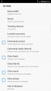
- Possibility to change tracking interval;
- Possibility to change location accuracy settings;
- Battery level percentage is sent together with every location;
- If Internet is lost, application will save locations and upload them later;
- Possibility to control application via web browser using commands;
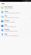
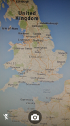
- Camera allows to make photos and upload to user account with last location;
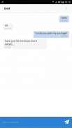
- Communication with main account via Chat;
- SOS long click button;
- Automatic startup on phone restart;
- Password protection;
- Application runs in background.
GPS-server.net features:
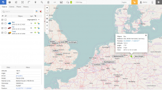
- In real-time tracking mode you will see your current location on the map, or the last position when your GPS device connection was active.
- Server can generate and send you notifications via e-mail or notify with a pop-up window, when something happens. That kind of events might be when object enters or exits geofence area, violates speed limit, presses SOS button, GPS device loses connection and even starts engine or opens door.
- With geofences you are able to make a virtual perimeter on geographic areas that have specific interest for you. The main reason to have Geofences is to control whether the units stays within it or not, so that when the geofencing unit enters or exits the area a notification is generated.
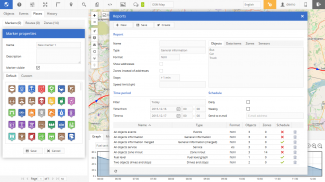
- POI (Points of Interest) allow you to put markers at the locations that might be interesting or useful. You can also name the place, add short description, attach an image or even video to it.
- The history of your tracks can be put on the map with addition information, such as time/speed graph, stops, reports, etc. There is also possibility to generate group reports for your objects.
- You can search for addresses from the search panel, enter point coordinates. Also you can use tools for calculating distances between places on the map and etc.
- Possibility to manage GPS devices on your own, add extra sensors. Customizable user settings.
- Mobile version of tracking application, which is designed to run on mobile devices.
ด้วยแอปพลิเคชัน GPS Tracker คุณสามารถแปลงอุปกรณ์ Android เป็นอุปกรณ์ GPS
วิธีใช้: http://www.gps-server.net/android
แอปพลิเคชันนี้อาจมีประโยชน์สำหรับ:
- ติดตามโทรศัพท์ของคุณออนไลน์ในเวลาจริง;
- บันทึกและตรวจสอบแทร็ค;
- กู้คืนโทรศัพท์ที่หายไป;
- ความปลอดภัยส่วนบุคคล
- ประหยัดเงินสำหรับเจ้าของธุรกิจ
คุณสมบัติ GPS Tracker:
- แอปพลิเคชันรับตำแหน่งโดยใช้ GPS และ AGPS;
- ความเป็นไปได้ที่จะเปลี่ยนช่วงเวลาการติดตาม;
- ความเป็นไปได้ที่จะเปลี่ยนการตั้งค่าความแม่นยำของตำแหน่ง;
- ร้อยละระดับแบตเตอรี่จะถูกส่งพร้อมกับทุกสถานที่;
- หากอินเทอร์เน็ตสูญหายแอปพลิเคชันจะบันทึกตำแหน่งและอัปโหลดในภายหลัง
- ความเป็นไปได้ในการควบคุมแอปพลิเคชันผ่านเว็บเบราว์เซอร์โดยใช้คำสั่ง
- กล้องช่วยให้การถ่ายภาพและอัปโหลดไปยังบัญชีผู้ใช้ที่มีตำแหน่งสุดท้าย;
- การสื่อสารกับบัญชีหลักผ่านการแชท;
- ปุ่ม SOS ยาวคลิก;
- เริ่มต้นโดยอัตโนมัติเมื่อรีสตาร์ทโทรศัพท์;
- การป้องกันรหัสผ่าน
- แอปพลิเคชันทำงานในพื้นหลัง
คุณสมบัติ GPS-server.net:
- ในโหมดติดตามเรียลไทม์คุณจะเห็นตำแหน่งปัจจุบันของคุณบนแผนที่หรือตำแหน่งสุดท้ายเมื่อการเชื่อมต่ออุปกรณ์ GPS ของคุณเปิดใช้งาน
- เซิร์ฟเวอร์สามารถสร้างและส่งการแจ้งเตือนให้คุณทางอีเมลหรือแจ้งเตือนด้วยหน้าต่างป๊อปอัพเมื่อมีบางสิ่งเกิดขึ้น เหตุการณ์ประเภทนั้นอาจเกิดขึ้นเมื่อวัตถุเข้าหรือออกจากพื้นที่ทางภูมิศาสตร์ละเมิดความเร็วที่กำหนดกดปุ่ม SOS อุปกรณ์ GPS ขาดการเชื่อมต่อและแม้กระทั่งสตาร์ทเครื่องยนต์หรือเปิดประตู
- ด้วย Geofences คุณสามารถสร้างขอบเขตเสมือนบนพื้นที่ทางภูมิศาสตร์ที่มีความสนใจเฉพาะสำหรับคุณ เหตุผลหลักที่จะมี Geofences คือการควบคุมว่าหน่วยอยู่ภายในหรือไม่ดังนั้นเมื่อ Geofencing หน่วยเข้าหรือออกจากพื้นที่การแจ้งเตือนจะถูกสร้างขึ้น
- จุดที่น่าสนใจ (POI) ให้คุณใส่เครื่องหมายที่สถานที่ที่น่าสนใจหรือมีประโยชน์ นอกจากนี้คุณยังสามารถตั้งชื่อสถานที่เพิ่มคำอธิบายสั้น ๆ แนบภาพหรือแม้แต่วิดีโอ
- ประวัติของแทร็กของคุณสามารถวางบนแผนที่พร้อมข้อมูลเพิ่มเติมเช่นกราฟเวลา / ความเร็วหยุดรายงาน ฯลฯ นอกจากนี้ยังมีความเป็นไปได้ที่จะสร้างรายงานกลุ่มสำหรับวัตถุของคุณ
- คุณสามารถค้นหาที่อยู่จากแผงการค้นหาป้อนพิกัดจุด นอกจากนี้คุณสามารถใช้เครื่องมือสำหรับการคำนวณระยะทางระหว่างสถานที่บนแผนที่และอื่น ๆ
- ความเป็นไปได้ในการจัดการอุปกรณ์ GPS ด้วยตัวคุณเองเพิ่มเซ็นเซอร์พิเศษ ปรับแต่งการตั้งค่าผู้ใช้
- แอปพลิเคชั่นติดตามเวอร์ชั่นมือถือซึ่งออกแบบมาเพื่อใช้งานบนอุปกรณ์มือถือ


